Walking Guide to Historic Milton NSW
Take home more from your visit to Milton with a walk around its historic town buildings and charming late 19th to early 20th century homes.
Milton main street walk, plus two extension walks
The main street walk, Walk A, is about 900m and you can add two extension walks. The Walk B loop to the north is an extra 340m, and the Walk C loop to the south-east, adds another 1.8km. Each of the walks has stops at historic buildings and sites along the way, numbered A1 to A17, B1 to B3 and C1 to C22 for each loop.
You can access this guide one of three ways: using this online version, downloading a PDF you can use offline on your device such as a smart phone or tablet, or downloading a PDF that’s suitable for printing.
Walking Guide to Historic Milton, NSW – PDF for phone/tablet
Walking Guide to Historic Milton NSW – PDF print version
Walking Guide links
Where to begin
Where to park
Public toilets
Acknowledgement of country
Milton settlement history
Milton architecture
Walk A – main street walk
Walk B – northern loop
Walk C – south-eastern loop
Where to begin
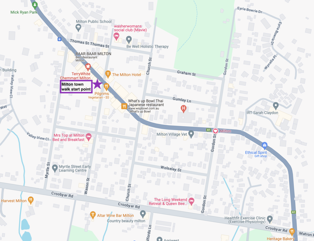
Walk A is a loop which starts and finishes on the south-west corner of Wason St and the Princes Highway. (see * on map, below)
Park your car
- in the free all-day carpark behind the shops on the south-western side of the highway and accessed from either Wason St or Myrtle Street
- park along any side street
- in the carpark on the eastern side of the Princes Highway behind IGA, and accessed from Church St.
Toilets
If you need a comfort stop during your walk, you will find public toilets next to Milton Library (Walk A), in Mick Ryan Reserve (Walk B) and in the hall behind the Church of St Peter and St Paul (start of Walk C). Further south, you can sample the coffee and baked delights of the Heritage Bakery to then use its toilets (Walk C).
Acknowledgement of country
Milton is on Murramarang country, part of the Yuin nation and Dhurga language group, and is overlooked by the sacred Didthul (Pigeon House) Mountain.

Didthul Pigeon House Mountain. An HC Blackburn postcard
Aboriginal occupation of the area extends back at least 20,000 years and the area has many fine examples of rock paintings, engravings and tool making. You can learn more about the indigenous history of this area by joining a local elder for a Coomee Nulunga Cultural Tour, named for Coomee Nulunga, aka Moriah/Maria, a well-known and respected local Aboriginal elder woman (1829-1914).
Milton settlement history
Milton is set among one of the most beautiful pastoral landscapes in Australia with rolling green hills and dairy farms dating back to the 1830s. If you explore some of the surrounding countryside you will find elegant mid- to late- 19th century homesteads and farm buildings at Mt Airlie, Boolgatta, Kendall Dale, Kirmington, Whoppindally, Narrawilly, Sunny Vale, Pine View, Mimosa Farm, Loch Leven, Avenal, Applegarth, Danesbank and Eyrie Bowrie.
British settlers first came to the Milton area to harvest the valuable red cedar trees but soon realised the farming potential of the surrounding nutrient-rich volcanic soil, known as Milton monzonite. Government land grants to settler farmers forced indigenous people off their traditional lands, confining those who stayed in the district to a designated ‘camp’ on the south side of Ulladulla harbour. Fortunately many did stay, and Milton-Ulladulla still has a vibrant indigenous community who pass on important knowledge of country.
The incoming settlers also developed a thriving timber industry, cutting the tall, straight local trees such as spotted gum (Corymbia maculata) and blackbutt (Eucalyptus pilularis) for export to the Illawarra region and Sydney for building, railway sleepers and mine timbering. Along the elevated ridgeline from Stony Hill settlers built homes at ‘The Settlement’ (now Milton), and also to the west on the fertile plain at Croobyar, and at ‘Boat Harbour’, now Ulladulla.

Milton Subdivision Plan 1860, as surveyed by Morton
Milton town centre was subdivided in 1860 by speculator John Booth on land bought from Joseph Whatman of Myrtle Farm. The 32 lots sold in the area were bounded by Myrtle St, Thomas St, Church St and Croobyar Rd, with the Southern Rd (also locally known as Murramarang St, or also simply ‘Main St’, and now the Princes Highway) crossing it at an angle, causing some unusual block shapes and intersections. Streets were named for family and friends and the building lots sold quickly for up to £27 each.
Nobody knows for sure why the town was called Milton. John Booth had a cousin who owned Milton Park in Bedfordshire. Another story says that Booth was a fan of the English poet John Milton who wrote ‘Paradise Lost’. Yet another version has the first post master George Knight, naming the town after his house, ‘Milton’, as he ran the business from there.
Milton grew and prospered over the following century, becoming a thriving centre for the local industries of dairying, timber getting and silica mining. Although Ulladulla was the all-important port, Milton became the main commercial and shopping precinct for the entire district, with Ulladulla only moving ahead as the commercial centre since the 1970s.
That Milton became the commercial and local government centre, and the fortunes of Ulladulla declined from 1860 until about 1970 has a lot to do with the long and bitter feud between two local wealthy landowners and brothers, David and James Warden. Their feud and the way it split the district into those who supported David Warden (Mayor and magistrate) and those who supported James Warden (member of the NSW Parliament and magistrate) affected everything about the development of the two towns, such as the location of major roads, the post offices, the courthouse, where schools were built, and where settlement and business expanded. And Milton and Ulladulla are still affected by it today – close, but distinctly different, friendly but still rivals.
Milton architecture
Several of Milton’s main street public buildings date from the late 19th century and the surrounding streets have many fine examples of late Victorian cottages with their symmetrical layout, weatherboard cladding, steeply pitched ‘corrugated-iron’ roofs, and 4-6 post front verandahs. Among them you will also see layers of later buildings such as Federation and 1920s bungalow-style houses with single or double gables, post WW2 cottages with hip roofs, and also mid-century homes featuring corner windows and flat steel roofs.

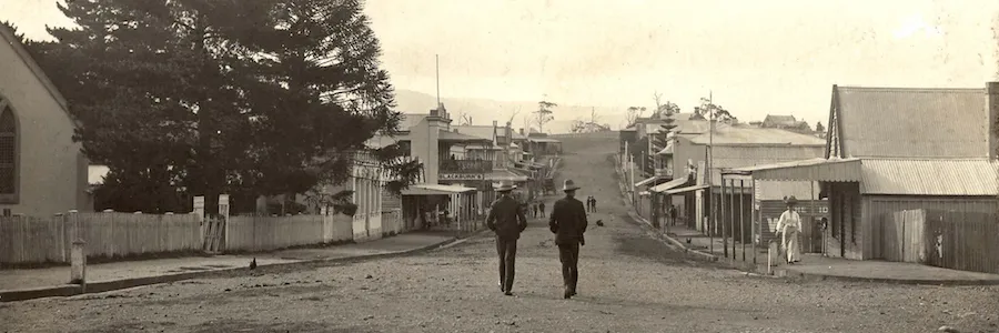
Milton’s Murramarang or Main St (now Princes Highway), looking south east from near the corner of Myrtle and Thomas Streets. From a postcard dated 1908
Walk A – The Main Street Walk – 900 metre circuit on a level grade. All paved
Begin your walk on the south-west corner of Wason St and the Princes Highway (see * on map, above).
Note that the buildings are listed in order along the side of the Princes Highway that you are walking. However you will find that viewing them again from across the other side of the Highway will give you a better view of their overall architecture.
Walk north-west (uphill)
A1. 69 Princes Highway – Milton School of Arts/Town Hall (now Milton Library)
Built in 1871 by public subscription as a School of Arts, it was designed by T.O Charter and built by John Porter of Milton. Many townspeople enjoyed educational lectures and lantern slide nights held here. In 1874 the newly-formed Council of the Municipality of Ulladulla rented space here for its meetings for several years, then moved to Wason St (east side) into a timber-lined corrugated iron building. In 1927 it finally bought the School of Arts and moved back in, no doubt a welcome improvement in accommodation. The Council then renamed it the Town Hall, changing the sign on the building’s facade. Money from the sale funded the building of the ‘New School of Arts’, now the Milton Theatre, next door.

School of Arts, Milton NSW c.1910. Note original facade sign says ‘School Arts 1871’, not ‘Town Hall’ as it does today
After WW1 it was used as the ‘welcome home’ venue for returning servicemen and women, including decorated local nurse Kitty Porter and Military Medal winner Private Jack Jones. You can imagine the scene – the building decorated with Union Jacks and Australian flags, the Milton Town Band playing, the crowd of men in their best suits and ladies in white dresses with giant hats, and then the cheers as everyone pushes forward as the motorcar arrives, bringing their local hero home.
Since the 1980s it has been used as a library, although it came close to being closed down a few years ago and was only saved by the quick thinking and dedication of group of local volunteers.
You will notice a small annexe on the left side of the building – originally there was a matching annexe on the right side too, but it was demolished to make room for the Milton Theatre.
A2. 69 Princes Highway – Milton Theatre
Built in 1927-1929 from the proceeds of sale of the School of Arts to the Council, this building was originally called the “New School of Arts, Milton”, and was used as a dance hall and picture theatre. During the days of silent films, intermission entertainment included magicians, singers and even a woodchopping contest on the stage.

Milton street scene in the 1930s showing the ‘New School of Arts’ (built 1927), now the Milton Theatre. Bartlett’s bus travelled from Nowra to Moruya
Since then it has also been used as a community events centre and a cinema from 1952-1962, and also again from the mid-1970s. Today, the Milton Theatre is a much loved venue for live music, festival events and annual shows performed by the Milton Follies and the Milton Entertainers. It has stall seats and a small dress circle.
A3. 67 Princes Highway – Hindmarsh House
Dating from 1873, this classic Victorian-era brick residence was built as a private home for William Rutter Hindmarsh, whose initials ‘WRH’ can be seen over the door. Hindmarsh farmed out at Croobyar and played a major role in introducing Australian Illawarra Shorthorn cattle to the Milton area. He was also a local magistrate, dedicated pigeon shooter and stalwart of the Agricultural Society, often winning prizes for his vegetables.

Hindmarsh House, was Thompson’s Bakery in late 1970s
If he and his family ever lived in this house it was only for a very short time as by mid 1873 he had sold up all his property in the district and moved back to his home town of Gerringong. The building was later used as a telegraph office in 1876, and also as a bank, and by Dr Renwick as his surgery in the early 1900s. Most locals know it as ‘Thompson’s Bakery’, which it was during much of the 20th century. It was beautifully restored and renovated in 2014-15 but is still unoccupied.
A4. 61 Princes Highway (north-west corner of Myrtle St)
Built in 1886, these corner buildings are now clothing shops and a solicitor’s office. In the 1950s-60s, Peter Gatehouse ran his ‘Electronic Devices’ business from here. He also used to startle the town by broadcasting his favourite music on Saturday mornings through speakers that he had rigged up on telegraph poles down the main street of Milton. Peter favoured light classics and popular tunes – and of course, he could then sell you the record from his shop.
Optional Walk B Loop
From 61 Princes Highway on the corner of Myrtle St, take the 340m Walk B extension loop by continuing north up the highway or, to continue the Main Street walk, cross the Princes Highway to the corner of Thomas St.
A5. 1 Thomas St – former Wesleyan Methodist Parsonage
Built in the early 1860s as a parsonage for the first Wesleyan minister on land donated by Henry Claydon. Although local folklore says that the parsonage was not occupied by Wesleyan ministers because the church hierarchy and the minister thought it was too grand, this is unlikely as several other similar buildings were used by Methodist ministers in NSW. The first minister, Rev J. Zillman was a single man who, not surprisingly, preferred to board with a local family, as did many subsequent unmarried ministers. However records show that Rev George Pickering and his wife Martha lived here in the 1870s.
The old parsonage was finally sold in 1929 and has been used as a residence, a hostel and, during WW2, as a surveillance post for spotting enemy aircraft.
Walk a little further down Thomas St to see Milton Public School
A6. 9 Thomas St – Milton Public School
The establishment of Milton School was one example of bitter rivalry during the 1860s-70s between David Warden of Croobyar (to the west of Milton, along Croobyar Rd) and a Milton town faction, headed by John Miller and supported by David Warden’s estranged brother James Warden, with whom he feuded for decades. David Warden wanted Croobyar to become the main town while Milton’s residents were just as passionate about promoting their town by getting government institutions established there. The argument over a Croobyar v Milton public school went all the way to the NSW Governor, who sensibly declined to get involved. Finally the Council of Education chose Milton as the place with the most rapid population growth.

Milton Public School c.1900. Milton NSW
The school’s original ‘rustic Gothic-style’ rendered sandstock brick building, designed by GA Mansfield, was built in 1877-78, alongside a four-roomed brick residence for the appropriately-named first school master, Henry Skillman. By 1895 the school had 183 pupils. A most-feared headmaster of the early 1900s, William J Healey (nicknamed ‘Rufus’) was notorious for his code of ‘spare the rod and spoil the child’, regularly wielding of a 4 foot long cane to discipline the children. Thankfully very different from the supportive and inclusive educational style of today’s school.
In the grounds of the school is an old timber classroom moved to the site from Brooman School in 1969 and also a Henry Kendall memorial garden built in 1966.
Cross back over Thomas St and walk across Milton Memorial Park to the Princes Highway
A7. Milton Memorial Park and Cenotaph
This park was created on the site of Pickering’s A1 Cash Store, demolished by Shoalhaven Council in 1979. Pickering’s was a two-storey masonry building with large verandah, built by Samuel Pickering, son of the Wesleyan minister. The A1 cash Store was later operated by Mumford and then Bedford.

Pickering’s A1 Cash Store once stood where the Milton Memorial Park is today, just south of the corner of Thomas St and the Princes Highway, Milton NSW
The war memorial granite obelisk on the corner of the park was dedicated in 1923 and is inscribed with an honour roll of those from the Milton district who served during WW1 and WW2, including nurse Sister Kitty Porter awarded a Red Cross Medal in 1919, Cecil Baxter the Distinguished Conduct Medal (WW1), and Military Medals to William Booth, Walter Bishop, Thomas Duffy, William ‘Jack’ Jones and Edward King.
A8. 64 Princes Highway – Milton Courthouse
As Milton grew, the local court was moved here from Ulladulla in 1877, including fixtures and fittings from that building, despite the protests of Ulladulla residents who had donated them. The 1870s building with a police station at the rear was designed by Colonial Architect James Barnett but soon became too small for the court business of a growing town, so a new courthouse was designed by Walter Vernon. While the government initially considered the cost for this Federation-style courthouse to be too high, this handsome building was finally constructed in the mid-1890s after the original courthouse roof fell in.
Apart from the usual small crimes of petty theft (usually stealing animals), and being drunk and disorderly, Milton was so law-abiding that the Ulladulla and Milton Times suggested in early 1905 that “the people will have to stir themselves up a bit and run foul of the law a little more often than has been the case in the past, else we might lose the police court“. Fortunately for Milton, a minor crime wave must have followed as the Milton Courthouse is still used Tuesday to Thursday for the Milton Local Court.
A9. 66 Princes Highway – Milton Post Office
Milton’s first post office opened in January 1860 after vigorous petitioning by its wealthier residents, who saw it as essential for the new town’s future. This was equally vigorously opposed by Boat Harbour (Ulladulla) Postmaster, David Warden, who didn’t want its importance as the government centre diminished and claimed that most Milton inhabitants were illiterate anyway. After much impassioned letter writing by both parties, a somewhat bemused Post Master General approved the Milton licence but also continued that of Boat Harbour.

Milton Post Office single storey c.1900
The Milton post office was in various locations around the town until the original single storey building on this site, designed by NSW Government Architect WL Vernon and built by James Poole was finished in 1880. It had two porticos supported by square columns and a hip roof. Renovations in 1895 produced the unusual half circle window and a gable roof, and then the second storey was added in 1904.
A10. 72 Princes Highway – Mellick’s Corner
Cec Mellick, who arrived in Milton in 1938, was its most eccentric shop owner. A renowned collector and hoarder, he created a drapery and emporium-style shop plus offices in the 1950s by building a new shopfront along the highway and also cobbling together a number of repurposed old buildings, including the former corrugated-iron Council chambers around the corner in Wason St.
Cec was notorious for refusing to serve customers if he didn’t like something about them (for example, if they came from Victoria), for reciting lengthy passages of Shakespeare, or loudly offering unasked-for advice. But he was also a gifted glass-worker and cabinet-maker, and was very generous to local charities and to his community.

Mellick’s Corner in the 1970s
Cec Mellick sold his property to Shoalhaven Council for $1.00 in 1991 but could continue his use of it until his death. But by the early 1990s the buildings had become derelict and unsafe, while still filled with a tightly-packed jumble of display cabinets, wood-working equipment and unsold items, including boxed shirts, vinyl kitchen chairs, leadlight windows, and a perplexingly huge stack of flyscreens. Despite Cec’s expectation that his buildings would be used as a community arts complex, and facing local opposition, Shoalhaven Council demolished those along Wason St and sold the land for development.
A11. 74 Princes Highway – Milton Hotel
Originally known as the Commercial Hotel, the single-storey building from 1871 was replaced with a handsome two-storey building around 1888, with an upstairs verandah and high-quality accommodation. The upstairs iron balustrade was added in 1919.

Commercial Hotel, Milton NSW. Peace Day march, July 1919
Unfortunately unsympathetic modernisation in the late 20th century removed the verandahs and the Commercial Hotel lost much of its external charm. It has now been renovated as the Milton Hotel.
A12. 82 Princes Highway – Star Hotel
Edward Tydeman was the first licensee of the original single level timber-slab Star Hotel on this site in 1860. It possibly replaced Tydeman’s earlier Australian Hotel. After his death in 1865, his wife Charlotte took over the running of the hotel and became well-known as an excellent innkeeper. A second storey addition with a decorative timber verandah and impressive parapet was added in the late 1920s by Tom Cork (a renown teetotaller) and his wife Louise during their ownership 1906-1924. The Cork family expanded to the point that locals used to joke they were what kept Milton afloat.

Star Hotel Milton NSW. c1910
Starting in 1924, the facade of the Star Hotel has been very much altered, with an extension at its southern end, windows bricked-in, the removal of the balcony and verandah, and addition of a cantilevered awning.
Walk back to the pedestrian/traffic light crossing and cross the Princes Highway. Or you can also view most of these buildings from this (eastern) side of the highway.
A13. Corner of Princes Highway and 39 Wason St – formerly Faust’s Newsagency
Just along Wason St from its north-west corner was a newsagency and confectionary business, run by the Faust family. It’s distinctive triangular gable is now covered by a new facade. In the early 1900s, JM Faust’s six acetylene lights on 4.5 metre poles lit up the nearby intersection. This was to encourage night-time shopping, as Faust’s stayed open until 10pm and was a popular venue for an evening game of euchre, with the losers shouting a threepenny hop beer or halfpenny toffee bar for the winners.

Faust’s Newsagency in Wason St, Milton NSW, late 1930s
Unfortunately patriarch J.M. Faust’s Germanic origins gave the family considerable difficulty during WW1 – his name was removed from the electoral roll, his personal bank account was frozen and a small percentage of the town were openly hostile. This was despite him being a naturalised Australian citizen since 1892 and two of his sons serving in the Australian navy. Fortunately Faust, a man who had shown in many ways his love for Australia and Milton, had many more supporters than opponents and he stoically endured this adversity, and remained and prospered in Milton.
A13(a) Outside 43 Wason St – Domed well
Straight ahead of you at the end of the raised section of footpath on the north side of Wason St you will see a curious concrete dome, about 3 metres in diameter. This is one of the Milton district’s many wells, dating from the late 19th century, which were used by early settlers in the days before town water supply. They are now all covered with distinctive concrete domes. You can see other domed wells at the Milkhaus cafe and on Mollymook beach near the Surf Life Saving club.
A14. 93-97 Princes Highway – The Settlement
‘The Settlement’ includes a row of Victorian masonry shops built by John Kendall in the 1870s, used as the Australian Joint Stock Bank (until 1888), then as auctioneer’s rooms (including J Boag and later JF Wallace) and now as a clothing shop, Pilgrims Vegetarian Cafe and Peach Cafe. Note the original decorative render detailing above the windows and doors.
At the rear of The Settlement (accessed through a short arcade between Peach Cafe and Wild Ivy or another arcade further on beside Brown Sugar Cafe) are Frederick Hall’s weatherboard shop and residence c.1874 (now Country Leather), sold to HC Blackburn in 1881 and incorporated into his store and residence.
A15. 103 Princes Highway – former Blackburn’s ‘The Popular’ store (now Spaces 2538 and Wild Poppies plus upstairs shops and offices)
HC Blackburn and Sons established a thriving retail business in Milton known as Blackburn’s ‘The Popular’ Store from the town’s earliest days. In 1899 he updated his small shop and post office with a grand quadruple-fronted two-storey shop, including a beautiful iron lace verandah. The bricks were handmade locally in the Montgomery Brick Kiln on Narrawallee Creek. The store sold everything from fresh food to furniture and fashion, and hardware to homewares.

HC Blackburn’s ‘The Popular’ store, viewed from the south, 1911
Meeting under Blackburn’s original verandah (now removed – it was in front of of the current Milton newsagent) soon became the town’s social hub, especially during Saturday night shopping. HC Blackburn, compulsive beard-stroker, owner of Milton’s first car and frequent extender of credit to those going through hard times – used to enjoy standing on the verandah and throwing lollies down to the children on Empire Day. The original verandah was demolished and the suspended veranda added in the 1950s. Blackburn’s continued through three generations but was closed by John Blackburn in 1973 and the shop converted into multiple uses.
A16. 107 Princes Highway – former CBC Bank Building (now Coast Cafe and Specially Gifted)
Now hosting shops and cafes, the beautiful Italianate-style Commercial Banking Company of Sydney building with its decorative turrets and chimney pots, was designed by GA Mansfield and dates from 1875, with additions in the early 1900s. For the first half of the 20th century it was the only bank in the district.

Commercial Banking Company of Sydney in Milton NSW, and manager’s residence c1910
Take a short detour through to the Village Green, accessed alongside the old bank building. Enjoy panoramic views to the west, surrounded by cottage-style shops and several sign boards with further historical information about the Milton district.
A17. 111 Princes Highway – St Peter and St Paul Anglican Church
John Kendall dedicated the foundation stone of the Gothic-revival style Church of St Peter and St Paul on 21 August 1859, on land donated by Joseph Whatman of Myrtle Farm. The original church building (the long section with a tall arched window) was one of Milton’s earliest buildings, built by John Chandle and A. Bond in 1860. Lay preachers, such as Thomas Kendall, acted as clergymen in the early years as it took some time for the small congregation to attract a minister. Regular services began in 1869.

Anglican Church of St Peter and St Paul, Milton NSW original building, 1890s
The original building had a steeple added in the late 1800s and was extended in 1906-1907 by builders Mudge and Poole, adding a chancel, vestry, sanctuary and organ chamber as well as decorative windows. A small organ built by C. Richardson and Co of Sydney was installed in 1909 (restored in 2012).
In 1920, Alice Kendall planted the Chinese elm (Ulmus parvifolia) just inside the front fence. The weatherboard church hall behind the church fronting Church St, built by Mudge, dates from 1918.
The rectory, which stood alongside the church on the corner, was demolished in the 1960s.
From here you can turn around and walk back along the Princes Highway to finish Walk A at Wason St and the carpark, or you can take the Walk C loop extension
Optional Walk C loop
From the Church of St Peter and St Paul you can add the 1.8km Walk C loop continuing southwards along the Princes Highway to Croobyar Rd then back via Wason St to the carpark.
Walk B – Northern Loop
A 340 northern loop between the corner of Myrtle St and the Princes Highway (Stop A4) and the Weselyan Methodist Parsonage (Stop A5) – adds 340m on a level grade. Some unpaved footpath.
From the corner of Myrtle St (stop A4) continue on the same side of the highway for 150 metres to Times Past B&B
B1. 51 Princes Highway
Built in about 1890 this late-Colonial style building was the homestead of one of the first dairy farms providing town milk.
Walk next door to the Heritage Fig in Mick Ryan Park.
B2. 49 Princes Highway – Mick Ryan Reserve and the Heritage Fig
This huge small-leafed fig (Ficus obliqua), with its 40 metre-wide canopy is a district icon and listed on the National Register of Big Trees. Probably every child born in Milton has climbed its majestic limbs or played hide-and-seek around its buttressed trunk. Local stories suggest a planting date during the late 1820s.
From the Heritage Fig cross the highway and walk southwards past several 1900-1920s cottages
B3. Corner Thomas St and Princes Highway Milton – Whatman family cemetery
Almost hidden between 56 Princes Highway and the former Wesleyan Methodist Parsonage is a small triangle of land which old records indicate is the burial place of Joseph Whatman, original owner of Myrtle Farm, bought by John Booth for his Milton town subdivision in 1859.
Now continue Walk A, the main street loop walk, beginning at 1 Thomas St, the Wesleyan Methodist Parsonage (stop A5)
Walk C – South Eastern Loop
An 1800m extension loop from the Anglican Church of St Peter and St Paul (stop A17) back to the Wason St carpark. Grass (unpaved) footpaths and some moderate slopes.
NOTE – many of the historical buildings and sites listed here, including former churches, are on private property. While they can be viewed from the street, they are not open to the public, so please respect the privacy of owners and occupiers.
From St Peter and St Pauls Church continue south on the same side of the highway (west side) for 850 metres. The buildings listed are on both sides of the Princes Highway, shown by E or W on their listing
C1. 92 Princes Highway (E) – Woodstock Chocolate Co.
Dating from the early 1890s, this rendered Victorian two-storey corner building was Allan’s Milton Bakery. It still has its original parapet but the elegant two-storey verandah has been removed.

92 Princes Highway, the two-storey building on the corner of Church St east side (now Milton Bakery), early 1900s
Continue on past several charming early 20th century cottages, several now repurposed as professional rooms and medical clinics
C2. 131 Princes Highway (W) – former doctor’s surgery and dispensary, now part of Milton Medical Centre
A Victorian Georgian-style masonry residence with a steeply-pitched hipped slate roof, this handsome building with its distinctive twin metal post verandah appears on some of Milton’s earliest photographs. Dr Nicholas Faust and Christian Koychen, pharmacist set up a practice here around 1874.

Early view of Milton looking SE from Church St, with 131 Princes Highway Milton visible in middle distance, c1880
C3. 141 Princes Highway (W) – former Salvation Army Hall (now part of Milton Family Medical Centre)
Built around 1900 and donated by William Garrad, the hall became the town’s centre for the Salvation Army, which came to Milton in 1886 and finally disbanded in 1932. The ‘Sallies’ band of drums and tambourines would often march into town on a Saturday night and play loudly outside the main street hotels. The Ulladulla and Milton Times reports in November 1892 that, in Milton, the Army can “number among our ranks some of those who were once the victims of drink, and whose vicious careers made them a standing menace to the more peaceably inclined citizens of Milton“.
C4. 122 Princes Highway (E – corner Gordon St) – former Lighthouse keeper’s cottage (now Lighthouse Medical Centre)
Really part of Ulladulla’s heritage rather than Milton’s, the lighthouse keeper’s cottage associated with the Warden Head lighthouse in Ulladulla was sold in 1922 when it became superfluous due to automation of the lighthouse. It was bought by Milton auctioneer John Boag who moved it here.

Warden Head Lighthouse at Ulladulla and lighthouse keeper’s cottage in original location c.1910
C5. 128 Princes Highway (E) – Masonic Temple
Founded in 1878, Milton’s Masonic Lodge originally met in the town’s School of Arts. This brick building dates from 1923.

Masonic Temple Milton, NSW, in 1924
C6. 146 Princes Highway (E)
This interwar period home is an interpretation of Federation style but with fibre cement sheeting above sill height. The building is listed by the NSW Chapter of RAIA in its Register of Significant Twentieth Century Architecture.
C7. 150 Princes Highway (E) – ‘Melrose’
Set well back from the highway, ‘Melrose’ is a pretty Georgian-style farm cottage with hipped roof and four-post verandah, built in the 1880s for the Kendall family
Continue along the Princes Highway to Croobyar Rd and cross Croobyar Rd to the Heritage Bakery. On the other side of the highway 50m along (past the Heritage Bakery) is a timber slab cottage at 176 Princes Highway, thought to be one of Milton’s oldest buildings.
C8. 201 Princes Highway – Heritage Bakery
Built in 1842 and then repurposed as a general store by Adam McArthur in 1870, this classic stone building, originally built in the Georgian style without a verandah, is possibly the oldest commercial building in the Shoalhaven.

Heritage Bakery Milton NSW, in 1899 being used as HC Blackburn’s temporary store
It was used as a temporary store by HC Blackburn in 1899 when rebuilding his Milton main street shop, and has also been a restaurant. It is now a bakery, famous for its pies.
Cross back over Croobyar Rd and walk 100 m along Croobyar Road
C9. 10 Croobyar Rd – site of Anglican Pioneer cemetery
In 1859 Roger Seccombe sold this land to Milton’s Church of England of St Peter and St Paul as its burial ground. Although over 170 burials were recorded here, there were only a few dozen headstones as most families could not afford anything more than a timber cross. The last burial was in 1903, as by that time the site was clearly unsuitable as springs flowed through it to the nearby creek.

Church of England ‘Pioneer’ Cemetery at 10 Croobyar Road Milton NSW, April 1976
Sadly, over a third of those buried here were children – many of them dying during epidemics of diphtheria, scarlet fever and typhoid in 1875-76. Decades of neglect and cattle roaming the site destroyed most of the headstones but many fragments remain below the ground, revealed by an archeological dig in 2011. The cemetery was sold to private owners in 1988. You can read more about the cemetery here.
Walk along Croobyar Rd for 300 metres to the former Congregational Church, crossing both Drury Lane and Gordon St. Note that Drury Lane is named not for the old nursery rhyme, but for the Drury family which ran most of the bullock teams used for dragging (snigging) cut timber from the forests to the mills.
C10. 38 Croobyar Rd – former Congregational Church and Manse
Congregational services began in 1872 after the church was built by stonemason James Poole from first class rubble masonry with dressed quoins and facings, and with elegant timber joinery by JB Moore. This handsome village church also has double glazed windows with cathedral glass, and a porch which was added in 1885 by Poole’s son, William Poole. The sandstock brick Manse behind the church was built in 1875, to save the minister his 30 miles of weekly travel from rented accommodation. The church’s burial ground is in the nearby locality of Woodstock.
In 1947, a wild winter gale blew off most of the roof and caved in part of the western wall causing extensive damage. Fortunately James Poole’s grandson George Poole was available to complete the restoration. This church became Milton’s Uniting Church in the 1980s however, by 2017, with the number of local worshippers falling, services moved to Ulladulla and the church was sold to private owners.
Walk along the northern side of Croobyar Rd to Wason St and then cross Croobyar Rd to the former Methodist Church.
C11. 71 Croobyar Rd – former Wesleyan (later Methodist Church) plus Sarah Claydon grave, now ‘The Old Church, Milton’ (in front of the Altar Bar)
This beautiful Victorian Gothic-style stone church is built on land donated by ex-convicts Henry Claydon and William Jinks. Designed by Colonel Thomas Rowe, it is constructed from coursed rubble walls with ashlar quoins and replaced an earlier timber building.

Wesleyan Methodist Church Croobyar Rd Milton c.1890s
The church opened for services in June 1883. It was extended in the early 20th century and also features a WW1 commemorative stained glass window.
After services moved to the Uniting Church, the church was sold to private owners in 1982. The building was internally renovated as a private home but is now used as a wedding venue and weekend bar and can be inspected by appointment.
It is the only Milton Church surrounded by its parish graveyard and has the grave of local ‘angel of mercy’ Sarah Claydon, a woman who devoted her life to the sick and needy in her district, particularly as a midwife, and refused all payment for her services. Her headstone reads “I was sick, and ye visited me”.
Cross back over Croobyar Rd and walk northwards up Wason St
C12. 69 Croobyar Rd – Mudge’s Corner and Turnbull’s Antiques
The long shed, which now houses Turnbull’s Antiques was used as a cordial factory in the early 1900s. Cordial makers made aerated drinks, including ginger beer and lemonade, for local customers in the days before refrigeration and international corporations like Coke and Pepsi.
Mudge’s workshops also housed a building company, a blacksmith and an undertaking business. The pretty timber Federation cottage fronting Wason St dates from 1906.
Walk up Wason St for 250 metres to see many well-preserved Victorian-era cottages. Buildings are shown as being either on the eastern (E) or western (W) side of Wason St
C13. 70 Wason St (E)
Victorian weatherboard worker’s cottage
C14. 66 Wason St (E)
Mid 19th century timber slab cottage, one of Milton’s oldest buildings
C15. 62 Wason St (E)
Late Victorian-era weatherboard cottage, renovated in the 1920s with a unique art-deco pressed metal hallway
C16. 73 Wason St (W)
Late Victorian weatherboard cottage
C17. 69 Wason St (W) – ‘Priaulx Villa’
Built by the Hamon-Pearce family in the 1870s and named for Rachel Hamon’s Guernsey-born father, Pierre Priaulx.
C18. 54 Wason St (E)
A Georgian-style Victorian-era brick cottage
C19. 63 Wason St (W) – now Mrs Top at Milton B&B
Victorian period worker’s cottage
C20. 61 Wason St (W, corner Charles St)
Victorian weatherboard corner store, used by John Bollingmore in the 1890s as a grocery and drapery in and, by 1905, WH Lander, solicitor
C21. 48 Wason St (E, corner Charles St) – the King House, now Legacy House
Georgian-style Victorian-era two storey brick residence, built about 1875
From here, look back down Wason St to compare with this early 1900s photo

Wason St Milton, looking south from Charles St to Croobyar Rd. King (Legacy) House near left, Mudge’s workshops end of Wason St right side, and former Wesleyan Methodist Church in distance
C22. 42 Wason St (E) – Donovan’s Cottage
Victorian-era weatherboard cottage built in 1870.
Walk C finishes where Walk A began, at the Wason St carpark.
COMING SOON!
- A Driving Guide to Historic Ulladulla
- Historic Sites of Milton, Narrawalle and Mollymook
- A Driving Guide to Historic Sites of the Lower Shoalhaven (from Bendalong to Durras)
Sources and other resources
The books listed are available for reading in Shoalhaven Library’s Ulladulla and Milton branches in the local studies section.
- Nulladolla – a history of the Milton-Ulladulla District by MUHS, 2013
- Meet the Pioneers by Joanne Ewin, 2004
- Memoirs of Mollymook, Milton and Ulladulla by Alex McAndrew, 1990
- Milton Ulladulla Historical Society archives and photograph collection
ulladulla.info/history
australianhistoryresearch.info - Historic Milton Walking Guide – Milton Promotions
© Milton Ulladulla Historical Society Inc, 2019