Landscapes and Localities of Milton-Ulladulla
The natural landscapes of Milton-Ulladulla are both dramatic, with rock-capped mountains and steep-sided, forested gullies and also peaceful, with long, sandy beaches and protected coves. Since settlement by Europeans in the early 19th century, human-influenced landscapes now dominate areas on the better class soils, creating beautiful rolling hills of green pasture that support dairy and beef cattle.
Human-shaped landscapes
Dairying
The volcanic Milton monzonite soils which cover a 10km band surrounding Milton grow rich pasture. By the 1860s, as the tall coastal forests were cleared and coastal shipping allowed access to markets, dairy farms were established across the area. This has created one of Australia’s most picturesque rural landscapes with rich grass-covered rolling hills and valleys intersected by many creeks. You can enjoy excellent views of this beautiful green countryside while driving southwards along the Princes Highway from Yatte Yattah to Milton and also out along Croobyar Road and Woodstock Road.
For a spectacular and sweeping view that shows the relationship of this fine dairy country to the surrounding forested hills and coast, drive the 7km to the top of Little Forest Road.
Timber cutting
Milton-Ulladulla is the southern-most growth range of the highly-prized red cedar (Toona ciliata syn. Toona australis), a subtropical tree used extensively in cabinet making in the 19th century. Red cedar logging first brought European settlers to Milton-Ulladulla in the late 1820s, however the tree was quickly cut out and timber getters turned their attention to the high quality towering hardwoods that covered the area, particularly eucalypts like spotted gum, ironbark and blackbutt and also turpentine.
The best quality timber was used for flooring and weatherboards. Larger, heavy pieces were also used in boat building and as bridge girders, wharf piles and telegraph poles, and smaller pieces for railway sleepers and mine timbering. Other local trees that were also harvested were black wattles (Acacia mearnsii) which has a tannin-rich bark that was stripped from the tree and used in the tanning process.
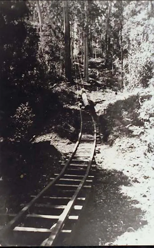
The remains of of the 60 timber mills between Nowra and Batemans Bay, and their associated tramways and wharves, are still dotted along the Milton-Ulladulla coast, in places like Bawley Point, Pebbly Beach, Kioloa and Durras.
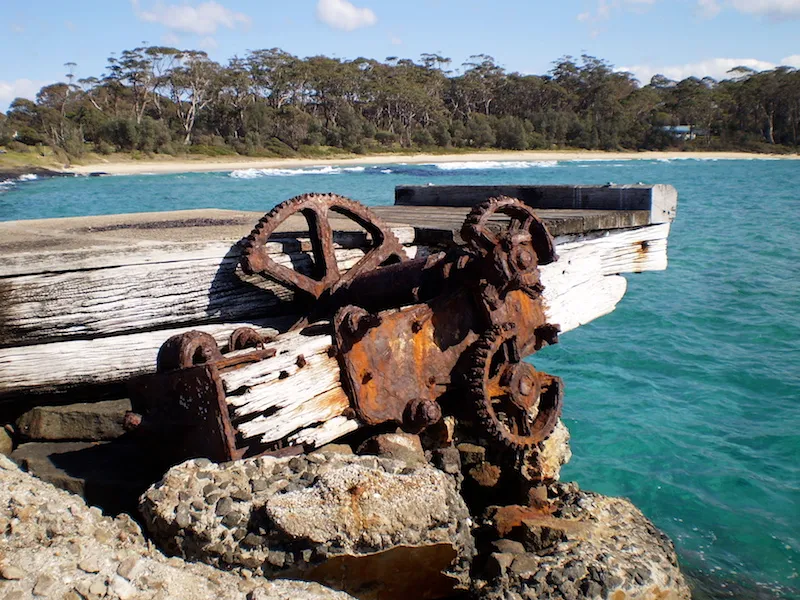
The jetty at Bawley Point was used to service the local sawmill. The small coastal steamers would moor close to the jetty and the milled wood was transferred to the ship by a flying fox. This is the remains of one of the winches
Silica Mining
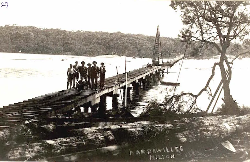
Silica is used in the manufacture of refractory bricks and the district had four sites where high grade quartzite ‘flint’ (from which silica is extracted) could be mined – Flint Point (just north of Collers Beach), the east side of the Princes Highway between Milton and Ulladulla, Bannisters Point and Bendalong. Mining began in 1917 with the rock broken up locally and taken by cart to Ulladulla for shipping. As the nearest silica was mined out, other sites were quarried and the rock was transported to Narrawallee Beach by a railway, first built from hardwood rails and then from Pattimores Lagoon across the Narrawallee inlet to Bannisters Head over a wooden bridge, where it was crushed and shipped. The hardwood rails were later replaced with steel rails.
In the landscape of the Narrawallee Creek Nature Reserve, you can see remnants of the silica mining which began in 1926 in pits, mounds, cuttings, and the line of the track. The bridge was dismantled in 1944 but you can still see some remnants.
In the landscape of the Narrawallee Creek Nature Reserve, you can see remnants of the silica mining which began in 1926 in pits, mounds, cuttings, and the line of the track. The bridge was dismantled in 1944 but you can still see some remnants.
One Track For All
Located at the northern end of Ulladulla Harbour, the 2km One Track For All is a cultural trail that tells the story of Milton-Ulladulla from an Aboriginal perspective, using stone relief carvings and paintings. Wheelchair accessible via Dolphin Street.
Natural Landscapes
Ulladulla Harbour Fossils
At low tide you can wander the tessellated rock platforms on the north side of Ulladulla Harbour and see countless Permian-era fossils from 270 million years ago. Begin with a 250m ‘walk through prehistory’ along the Geological Time Walk in Brodie Park which explains the evolution of Milton-Ulladulla’s geology and fossil beds. Look in the reddish patches of rock for fossils of sea fans, sea lilies, brachiopods, bivalve molluscs and corals, as well as burrows and feeding trails. For more information about Ulladulla’s fossils, visit ‘Fossil House’, located in Ulladulla’s oldest building on Green Street, just off the Princes Highway.
National Parks and Nature Reserves
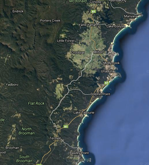
Because of the difficulty of building roads along the NSW South Coast, its development has been slower than the North Coast, leaving much of its wilderness undisturbed, to then be set aside in more recent years as National Parks. A quick look at a satellite view of the Milton-Ulladulla area shows it surrounded by four National Parks – Meroo, Conjola and Murramarang and the huge Morton National Park which stretches from the NSW Southern Highlands southwards to Milton-Ulladulla.
Many areas within the national parks show a rich history of more than 20,000 years of Aboriginal occupation, with hundreds of recorded sites revealing middens, stone and bone tool making, and rock and cave art.
Meroo National Park
This 3,826 hectare park is in two separate parcels, extending from 5km south of Ulladulla to Lake Tabourie, and also from Lake Tabourie to Bawley Point. It was gazetted in 2001 to protect coastal dune, lakes and foreshore land.
Conjola National Park
Comprising 11,060 hectares, Conjola National Park was gazetted in 1994 and runs from Sussex Inlet to Lake Conjola, encompassing coast, estuaries and inland sandstone country.
Narrawallee Creek Nature Reserve
Covering 878 hectares and just seven kilometres north of Ulladulla, this reserve was dedicated in 1986 and protects beaches, estuarine wetlands and freshwater lagoons like Pattimores Lagoon.
The northern end of the reserve, on a ridge just below Pattimores Lagoon was the site of silica mining from 1926 to 1975, and while walking along the Silica Ridge Trail you can still see many cuttings, mounds, pits and the old timber railway tracks that were used to transport the silica, first in horse-drawn iron skips and then by train and locomotive to a wharf for shipping. Silica was used in the manufacture of refractory bricks in Port Kembla.
Morton National Park
At nearly 200,00 hectares, this massive Park is the 5th largest in NSW. It began as a much smaller ‘Primitive Reserve’ in 1938 after much campaigning by locals and NSW MLA Mark Morton. The Reserve’s trustees protected it from logging claims and it was gazetted as a National Park in 1961 and was renamed to honour Morton. Pigeon House Mountain Didthul, at 720m high, is one of its most significant features.
Yatteyattah Nature Reserve
Created in 1996, the 19 hectare Yatteyattah Nature Reserve is 2.5km west of Lake Conjola and on the western side of the Princes Highway. It protects a remnant of the southern-most occurrence of dry-subtropical rainforest vegetation which was once common on volcanic Milton monzonite soils. The land for Yatteyattah Nature Reserve, originally Armstrong Forest, was donated by Mr. A McLean in 1890 and became a popular place for picnics, especially walking to the waterfalls along Currawar Creek.
Murramarang National Park
Running south of Ulladulla along the coast, the 11,978 hectare Murramarang National Park was first established in 1973 as a much smaller park and then added to over the following decades, largely due to the efforts of the local conservation group Friends of Durras. It contains picturesque Pretty Beach, Pebbly Beach, Depot Beach and North and South Durras which attract thousands of tourists., and also has many Aboriginal historic sites including extensive middens, and those showing tool making of stone tools, bone points and fishing hooks, indicative of a long period of occupation.
Brush Island Nature Reserve
This small 47 hectare island 600m off the coast between Bawley Point and Kioloa supports breeding populations of little penguins, wedge-tailed shearwater and white-faced storm petrel, plus a large number of fossil beds and undisturbed Aboriginal sites. In 1932, the Northern Firth was shipwrecked on the shore of Brush Island.
Murramarang Aboriginal Area
Described as one of the biggest and most significant Aboriginal sites in coastal NSW, the Murramarang Aboriginal Area on Murramarang Point is between Bawley Point and Kioloa and faces Brush Island. It contains the largest midden on the South Coast plus stone artefacts and bone tools and plays an important part in Dreamtime stories and beliefs.
State Forests
- Yadboro State Forest
- Clyde State Forest
- Termeil State Forest